Member Bands
| Council Members (Bands) | Total Population (Dec 2025) | Reserves # | Net Financial Assets $ | Accumulated Surplus $ |
|---|---|---|---|---|
| Kamloops | 1616 | 6 | 85,882,993 | 183,747,585 |
| Skeetchestn | 590 | 4 | 67,688,264 | 85,008,183 |
| 2206 | 10 | 153,571,257 | 268,755,768 |
Overview
The SSN is effectively an unofficial tribal council not involved in the BC treaty process, it is not included in the official Statement of Intent database, and it does not have a tribal council code designated by the federal government.
The SSN is an alliance between Tk’emlúps te Secwepemc (Kamloops Indian Band) and Skeetchestn. Both of these bands are also members of the Shuswap Nation Tribal Council, which has its own territorial claim, although the SSN appears to be a detached organization.
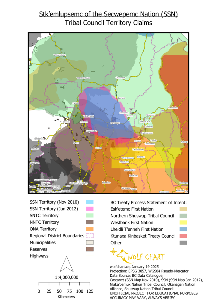
The origins of the SSN as an organization goes back to the 2000s, with an organized effort towards governmental legitimacy throughout the 2010s, especially in regards to the proposed Ajax Mine project. It was also in the 2010s when SSN produced two separate territorial maps; one was dated 2010 and recently published by Castanet, but the second one dated 2012 appears to be the official claim repeatedly published in SSN media and their website.
As is observable, the SSN territorial claim overlaps several other tribal council claims, as well as various reserves, municipalities, and other notable assets.
Land Claims
Overlapping Claims
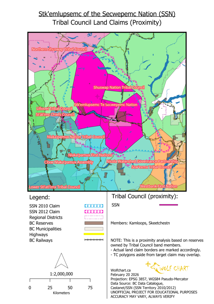
Proximity comparison of bands with land claims:
Overlapping Communities
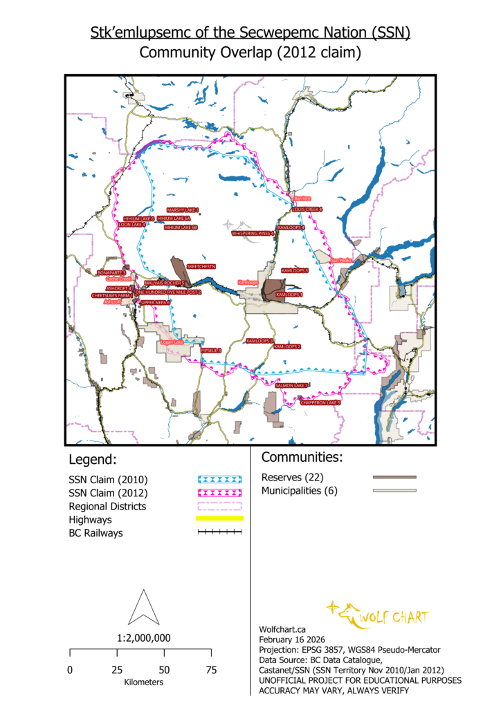
Reserves (22):
| CLAB ID | Reserve Name | Indian Bands |
|---|---|---|
| 7161 | ASHCROFT 4 | Ashcroft |
| 7165 | BONAPARTE 3 | Bonaparte |
| 7252 | CHAPPERON LAKE 5 | Upper Nicola |
| 7159 | CHEETSUM’S FARM 1 | Ashcroft |
| 7172 | HIHIUM LAKE 6 | Bonaparte, Kamloops, Upper Nicola, Lower Nicola |
| 7170 | HIHIUM LAKE 6A | Bonaparte, Skeetchestn |
| 7171 | HIHIUM LAKE 6B | Bonaparte, Skeetchestn |
| 7173 | KAMLOOPS 1 | Kamloops |
| 7174 | KAMLOOPS 2 | Kamloops |
| 7175 | KAMLOOPS 3 | Kamloops |
| 7176 | KAMLOOPS 4 | Kamloops |
| 7177 | KAMLOOPS 5 | Kamloops |
| 7166 | LOON LAKE 4 | Bonaparte |
| 7189 | LOUIS CREEK 4 | North Thompson |
| 9692 | MARSHY LAKE 1 | Skeetchestn |
| 7167 | MAUVAIS ROCHER 5 | Bonaparte |
| 7160 | ONE HUNDRED FIVE MILE POST 2 | Ashcroft |
| 7225 | PIPSEUL 3 | Lower Nicola |
| 7254 | SALMON LAKE 7 | Upper Nicola |
| 7169 | SKEETCHESTN | Skeetchestn |
| 7195 | UPPER NEPA 6 | Oregon Creek Jack |
| 8364 | WHISPERING PINES 4 | Whispering Pines-Clinton |
Municipalities (6):
| Census Subdivision ID | AA ID | Community Name | Community Type | Population (2021) |
|---|---|---|---|---|
| 5933019 | 152 | Ashcroft | Incorporated | 1670 |
| 5933074 | 157 | Barriere | Incorporated | 1765 |
| 5933024 | 158 | Cache Creek | Incorporated | 969 |
| 5933042 | 155 | Kamloops | Incorporated | 97,902 |
| 5933035 | 156 | Logan Lake | Incorporated | 2255 |
| 5933045 | 162 | Sun Peaks | Incorporated | 1404 |
The total population of these municipalities is 105,965.
Agricultural
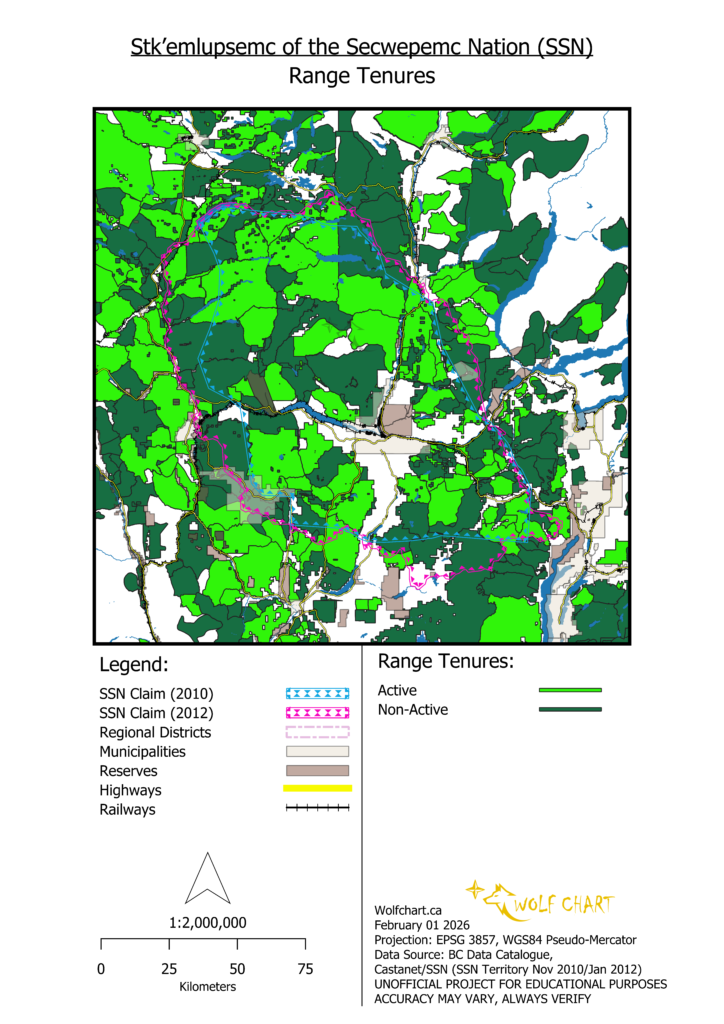
Range Tenure
Emergency Management
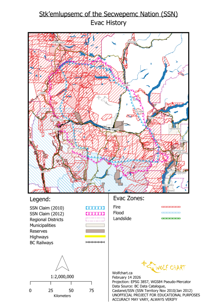
Evacuation Zones
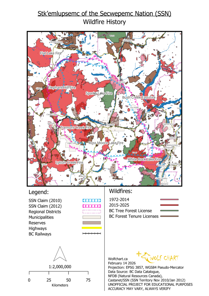
Wildfires
Industry
Mining
This map portrays SSN and other competing First Nation land claims over mineral resources located around Kamloops and neighbouring communities. Note that only selected strategic minerals are highlighted. The mineral polygons in the background are based on proximity between the points (depicted as crosses).
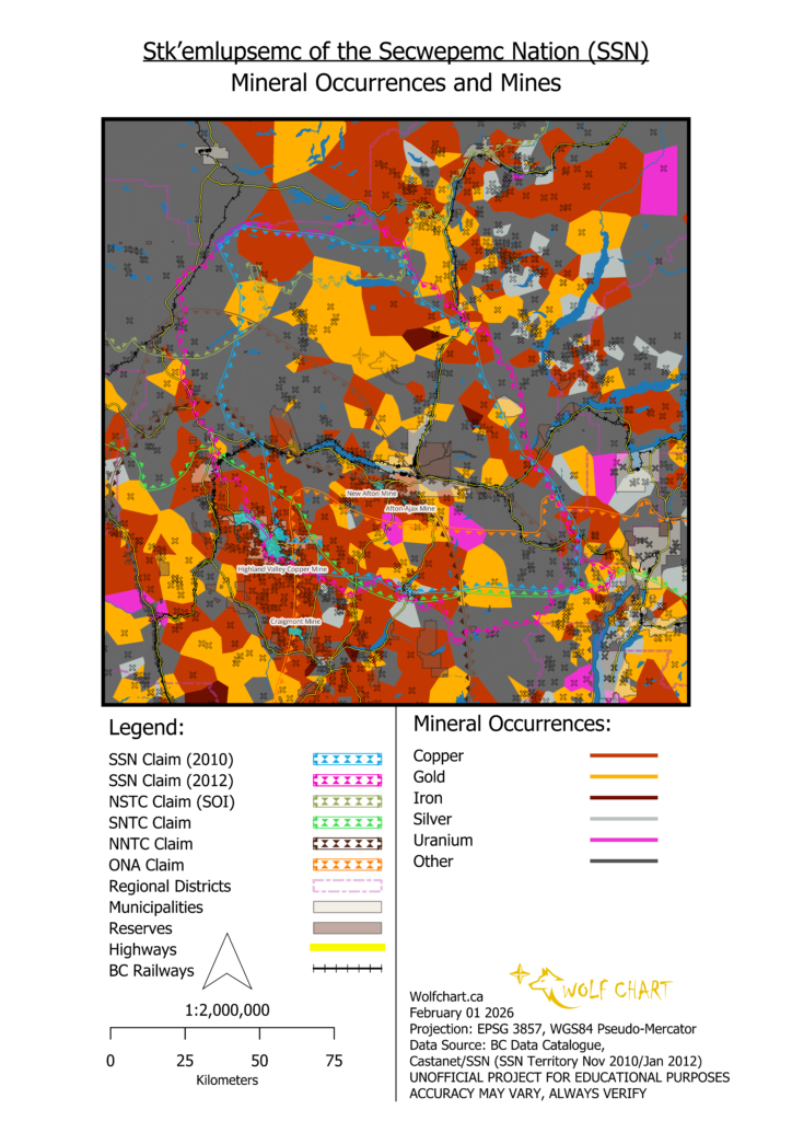
This map depicts a lot of important information. First of all, the area around Kamloops is loaded with significant gold, copper and silver deposits. Secondly, there are several First Nation tribal council land claims that overlap all of this area. Highland Valley Copper, New Gold (New Afton) and the proposed Ajax Mine are all within the Nlaka’pamux Nation Tribal Council’s exclusive territory. The Okanagan Nation Alliance also contains part of Logan Lake and the Highland Valley Copper permit zone.
It is particularly interesting that that the NNTC exclusive zone would cover the Ajax Mine site, seemingly all the way to the southern edge of Aberdeen. Back in 2017, the Stk’emlupsemc Te Secwepemc Nation carried out a media campaign, publishing multiple articles and assessments and videos on how they disapproved of the Ajax Mine project because of their historical ties to a small lake nearby named Jacko Lake, which they refer to as a sacred site to their people named Pipsell. If the NNTC map is accurate here, and the NNTC has been operating for approximately 40 years, then this suggests that Pipsell was already claimed by the Nlaka’pamux Nation by 2017.
Further to this, the NNTC holds influence (and thus claim) over strategic assets within its exclusive territorial claim. For instance, Teck Resources LTD, on behalf of its Highland Valley Copper mine project in Logan Lake, has published land acknowledgements stating that HVC is “operating within the traditional territory of the Nlaka’pamux Nation”.
There is another interesting observation involving Highland Valley Copper: most of the SSN claim is covered by the Shuswap National Tribal Council, but the SNTC claim stops short of Logan Lake/HVC. Both Kamloops and Skeetchestn bands are members of the SNTC, but this suggests that the SSN is a means for Kamloops and Skeetch to lay claim to HVC without sharing that claim with the rest of the SNTC.
Natural Geography
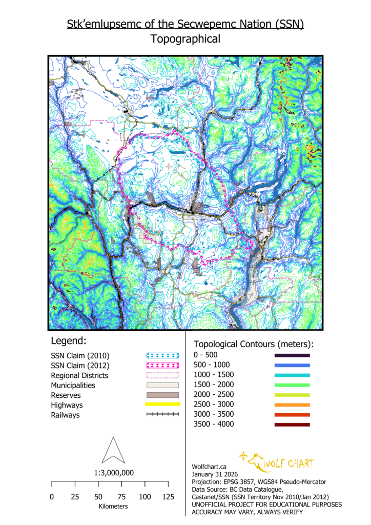
Topography
The SSN territory lays across the central plateau of the BC Interior. Its western and eastern borders the mountain ranges on both sides. It is also centered around the confluence of the North Thompson with the South Thompson River, a strategic location where Kamloops is located.
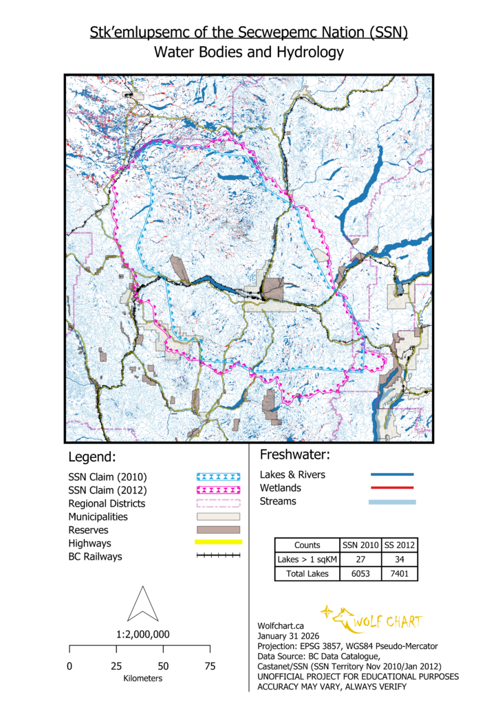
Water
This map depicts water bodies and flows in the region around Kamloops. This area is dense with streams in the watersheds leading into the Thompson Rivers. In the Sparks Lake to Green Lake area, northwest of Kamloops, there are also widespread wetlands. There are several large lakes of note as well, especially Savona/Kamloops Lake west of Kamloops, which is bordered by the primary Skeetchestn reserve.
Citations
Disclaimer
Updated February 14 2026